
Hiking The West Highland Way in 5 days as a solo female hiker
- daniellabarnes
- Jun 4, 2025
- 16 min read
Updated: Jan 10

The West Highland Way has been on my radar for a while now, so in early May I challenged myself to take on the walk solo and completely self supported. I chose to squeeze the walk into five days because well, that's all the time I had, your girl had to get back for rehearsals on the Tuesday night, and giving myself a generous two days to plan and pack before setting off, not giving myself very much time to plan or prepare but why change the habit of a lifetime.
Below I have detailed as much information as possible to help you plan your adventure. I've also included a day by day diary at the bottoms so you can enjoy my chaotic journey with me. Here's what I experienced hiking the West Highland Way in 5 days as a solo female hiker.
What is The West Highland Way?
The West Highland Way is a 96-mile (154 km) hiking route in Scotland, running from Milngavie near Glasgow to Fort William in the Highlands. The route passes through a variety of landscapes, including Loch Lomond and The Trossachs national park, as well as areas of countryside, loch shores, moorlands, and mountains. It was established as Scotland's first long-distance footpath and is now a highly popular route attracting visitors from all across the world.

What To Pack
I won't preach to you or lecture you on exactly what to pack, but I will share my list of everything I packed and some of the things that I would deem as essential for your journey. As with any outdoor activity in Scotland, you will likely encounter all weather conditions, so please make sure you take appropriate clothing options to reflect this.
I managed to fit and carry all of the below in a 42 litre backpack which weighed around 11kg.
Camping Equipment
Tent (Forclaz 2 person)
Sleeping bag (Rab Solar Eco 3)
Sleeping bag liner
Blow up mat & pillow
Water Filter (I never actually used this)
Bivvy Bag
Hip Bag
Jet boil
Water - 1.5litre which I refilled
Freeze dried meals x 3
Cereal Bars
Some snacks
Camping mug
Garmin In Reach
Tripod
Battery Packs x 2
Solar charger panel (didn't use this)
Headtorch
Clothing
Trail trainers
Camp shoes
Hiking Trousers
Shorts
Hiking t-shirt x 2
Down Jacket
Waterproof Coat
Light hiking fleece x 2
Thermal base layers (top & bottom for sleeping)
Gloves
Beanie
Underwear
Waterproof trousers
Microfibre towel
Hiking poles
Dry sacks
Toiletries
Toothbrush
Toothpaste
Mouthwash
Sunglasses
Face Cream
Smidge - repellent
Sun cream
Tissues
Compeed blister plasters
Blister cream
Face wipes
Ear plugs


Obviously I started off wearing some of these things & I packed the very minimum when it came to clothing and I was quite light on the toiletries too (I'm a minger, what can I say). I also unintentionally forgot my hairbrush which saved some weight but caused some distress 😅. In hindsight, one thing I do wish that I had packed is a ground mat for underneath my blow up, as at night the temperatures dropped and it was really cold.
My Route Over 5 days

Setting off from Milngavie at around 10.30am on Friday morning and reaching Fort William by 12pm on Tuesday afternoon, using the following route;
Day 1 - Milngavie to Sallochy Bay - 24 miles
Day 2 - Sallochy Bay to Inverarnan (Beinglas) - 18 miles (short day but the toughest)
Day 3 - Inverarnan (Beinglas) to Inveroran - 21.5 miles
Day 4 - Inveroran to Kinlochleven - 19 miles
Day 5 - Kinlochleven to Fort William - 15 miles
If you would like to extend your trip to take a bit longer on the route I would recommend breaking up day 1 and/or 3 by stopping at Drymen or Tyndrum along the way. This would allow you to do the route over 6 or 7 days and would perhaps feel a bit kinder on your body.
Other suggested itineraries:
5 days | 6 days | 7 days |
Milngavie to Balmaha - 20 miles | Milngavie to Balmaha - 20 miles | Milngavie to Drymen - 12 miles |
Balmaha to Inverarnan - 21 miles | Balmaha to Inversnaid - 14 miles | Drymen to Rowanderran - 15 miles |
Inverarnan to Bridge of Orchy - 19 miles | Inversnaid to Crainlarich - 13 miles | Rowanderran to Inverarnan - 14 miles |
Bridge of Orchy to Kinlochleven - 21 miles | Crainlarich to Inveroran - 15 miles | Inverarnan to Tyndrum - 12 miles |
Kinlochleven to Fort William - 15 miles | Inveroran to Kinlochleven - 19 miles | Tyndrum to Kingshouse - 19 miles |
Kinlochleven to Fort William - 15 miles | Kingshouse to Kinlochleven - 9 miles | |
Kinlochleven to Fort William - 15 miles |
The route is very well signposted but I had downloaded the full route on Alltrails just so that I had a reference at all times. You can get 30% off Alltrails+ here.

Food for the Trail
I packed three freeze dried meals and picked up some snacks at Tesco's. I only ended up eating one of my freeze dried meals and opted to stop for food in pubs along the way. Admittedly, I don't eat enough whilst I'm hiking, and I know I should definitely have eaten more but my body just doesn't seem to want it. I would definitely carry more sandwiches and snacks if I were to do it again.
There are some fantastic pubs and food places along the way. Whether you are looking for food or for something to drink or just a wee rest, here are some of my recommendations:
Turnip the Beet - Milngavie to Drymen. A healthy deli stop at the start of your hike
The Beech Tree Inn - Before Drymen
The Drymen Inn - Drymen. Perfect if you are passing through or staying in Drymen
Oak Tree Inn - Balmaha. Just as you come down from Conic Hill. I love this place - amazing food, atmosphere and drinks
Inversnaid Hotel - Inversnaid. Perfect stop as it is right on the trail and right on the Loch Lomond
Stagger Inn - Beinglas Campsite. Quite expensive and they automatically add on a service charge but it's literally right on the trail so very convenient
*The Drovers Inn - is close to Beinglas Campsite but a little off route - maybe a 30 minute walk. If you have the energy to walk here, I would recommend a visit but for me on this occasion there was no way I was giving myself any further to walk
The Real Food Cafe - Tyndrum. Award winning fish & chips and they really are incredible
The Tyndrum Inn - Tyndrum. A nice homely pub feel, always busy but welcoming. You can also book in for a massage here which I believe needs to be pre-booked
Bridge of Orchy Hotel - Bridge of Orchy. A great stop on the way for food and drink
Glencoe Mountain Resort - Glencoe. Stop for a snack at the panoramic café at the ski centre. Yummy homecooked food with decent prices for the area
Kingshouse Hotel - Glencoe. A scenic stop for a drink in the walkers bar as you are passing, the food here can be quite costly and the main restaurant isn't always the most welcoming for walkers. You might be lucky to see the deer here on your visit
The Tailrace Inn - Kinlochleven. Good foor, good atmosphere but can be quite busy
Black Isle Bar - Fort William. Directly behind the end of the trail, good for Pizza & beer. But by the time you reach Fort William you will be happy just to be sat in a pub with your feet up. I'd recommend here or the Ben Nevis Bar
*I did not stop at all of the above places mentioned however I did pass them on the route or know of them from previous trips.


In additional to all the wonderful pub and restaurant options, along the way you will come across honesty boxes (I found these at the start of the hike more so than the end) which are filled with a variety of treats ranging from cakes, fresh fruit, energy gels, water, baked goodies...
These were always a welcome sight but make sure that you have change as there are no card payment options.
Where to Stay

There are plenty of hotels and bunkhouses along the way for you to stop at but I would recommend getting them booked as early as possible as I expect they will be sold out during the peak times.
I camped the entire way - two nights wild camping and two nights on a campsite. If you look at the maps you can plan out some perfect camping stops before setting off on your adventure, there are so many amazing spots I would have loved to stop at if I had been taking longer on the route.
Where I stayed:
Sallochy Bay - I needed to find somewhere to stay around the Loch Lomond area as wild camping without a permit is prohibited. Sallochy bay was perfect for the evening, right on the waters edge. I booked this the night before and it cost £12. There are toilets and running water here and although there are some ground and families it is a lovely peaceful campsite with a noise curfew of 10pm.
Beinglas Campsite - I hadn't planned to stay here but the way the terrain was on the approaching path made me worry that if I kept walking I wouldn't find a suitable spot for the night. I got booked in no problem at the reception and I think it cost around £16. This was a great choice as there were lots of amenities including a very well stocked shop, a pub serving food, showers, toilet facilities and a great atmosphere even if it was a little noisy with non WHW walkers overnight.

Inveroran, Wild Camp 1 - I found a lovely camping spot for the night near to Inveroran hotel beside a little river which was perfect
Kinlochleven, Wild Camp 2 - I settled for a camping spot not too far from the Ice Factor which was suitable for the night. I did notice that some people had opted to camp in the forest on the ascent coming out of Kinlochleven which also would be suitable.
Up next is my day by day diary but if you don't want to read me waffling on then you can skip to top tips here.
Day by Day Diary
Day 1 - Milngavie to Sallochy Bay, 24 miles

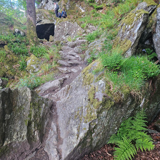
I left Dundee on the 7am train to Milngavie (which is actually pronounced as mul-guy and I've been saying it wrong my whole life). I really did pick the perfect week to do the trail as the weather has been beautiful. The night before setting off I had a terrible sleep, I was overthinking my route plans and whether or not I had packed everything. The first section out of Milngavie was through Mugdock Country Park - a relatively flat path through a forest full of ancient trees and flowing rivers, which was quite a lovely start but then you reach a bit which was mainly farm tracks and you could hear the passing traffic on the nearby road - you didn't feel very remote. I found the section just before Drymen pretty boring and it dawned on me here that I would very quickly have to get used to it as I'd be walking on my own for a very long time, round about here I swallowed a fly - protein. Thankfully I soon got chatting to a lady - Alex on the trail who walked at a very similar pace to me and we spent the day sharing stories. Alex is in her 60's and had flown all the way from Canada to take on the trail. This really made the day pass so much quicker. I was supposed to stop at Drymen for some lunch but when I realised I would have to leave the trail and then walk back on myself that idea quickly lost its appeal so I kept pushing on to Conic Hill with a hungry tummy and minimal snacks - schoolboy error. This part of the hike was much more scenic as you pass through the Campsie Fells and Conic Hill comes into view up ahead. I did notice a lot less people on this part of the route so I imagine most people chose to stop off at Drymen. The oath up to Conic Hill was not as steep as it looked and before long you were at the top gazing down over Loch Lomond in the distance. The descent from Conic annoyed me as the path is man made and the steps just don't fit your natural stride - I was really starting to notice the weight of my backpack here. When I reached the Oak Tree Inn I could have cried tears of either happiness and hunger 😅. I absolutely devoured Korean cauliflower and multiple pints of juice. Then I still had four miles to go to reach my camp spot - these felt like torture and I was nervous that I wouldn't make it there by 7pm. The traverse along the side of the Loch provided some beautiful scenery which made the journey feel a little less sore. Once arriving at Sallochy bay, I pitched up and a friend who lives near dropped by for a visit and with some lunch for the next day which was lovely. Disappointment quickly set in when I cooked my pork & rice freeze dried meal and realised I had forgotten my fork so I had to drink it - nice one! After an extremely long day of travelling and hiking, I got settled in for bed and the camp turned quiet around 10pm which was nice, it was super cold overnight!! Day one - done and dusted.


Day 2 - Sallochy Bay to Inverarnan (Beinglas), 18 miles
I awoke on day two to a beautiful dawn chorus of people farting from within their tents - the joys of a public campsite eh🤣I'm really immature so I found this pretty funny. I have to ay that this campsite is in such a beautiful location and the morning views of the Loch were incredible. On this morning I realised that I have in fact forgotten my hairbrush - this will not end well. As I set off from camp, I continued round the edge of the loch and past a tree swing which naturally I had to have a go on. Some steep stairs take you into the forest and I was serenaded by beautiful birdsong 😍.
Before setting off on the West Highland Way I kept hearing that apparently day 2 is really tough - I can confirm it is!!!
When I made to Rowanderran I popped into the shop for some snacks and to grab cutlery so I could eat properly. Shortly after Rowanderran you will come across Ben's bakes honesty box which was an absolute delight. It was stocked full of freshly baked goodies, fresh fruit, fizzy juice, water.... and wasn't overpriced either (£1.50 for a gel) I grabbed a gel and a banana and continued on my merry way. You reach a point of the track where you have the option to take the high road or the low road as the track separates for a short while;
Low road - closer to the loch, insane views but a lot of climbing up and down and over rocks and tree branches. More scrambly
High road - a better path through the trees, less views of the loch but easier to make pace
When the time came, I opted for the high road as honestly I just wanted to batter through the miles. After maybe a mile or two the road joins again and then the real fun begins, a never ending up & down path clambering over the rocks. Care should be taken here as a slip or fall could result in you going for a wee swim in the loch. Finally, I reached the Inversnaid hotel - at first I thought this was a mirage. There is a beautiful waterfall here, and the hotel is situated right on the loch - the perfect place to grab some lunch, I opted for scampi & chips. Continuing on from the hotel I walked through a forest lush with bluebells and wild garlic 😍. I met an absolute legend who was walking the West Highland Way from north to south but continuing all the way to Germany!!! I'll never complain about walking ever again!
There is a cute little bothy on the route which would be perfect for staying in overnight. When I reached Beinglas campsite, I intended to keep on pushing on but when I got there and saw there was a pub serving food literally right there I decided to stop here for the night which was a great decision as I made friends and it was really nice to sit and chat to people. During the night it was soooo cold, like there was ice on some of the tents, and some nutter was kicking off and banging doors in the early hours but other than that it was an absolutely great place to stop.
Day two might have been shorter, but it's a real workout with all those steps and rock climbs. It really tests your endurance.


Day 3 - Inverarnan (Beinglas) to Inveroran, 21.5 miles
I woke up pretty early and vacated the campsite at about 7.45am. Upon leaving the campsite you have a nice wooded walk with views of Ben More and Stob Binnein in the distance. I was really trying to slow my pace down today as I felt like I had been kind of racing with myself the previous days and I just wanted to slow and take it all in (I still ended up going pretty fast but at least the sentiment was there). The first section takes you alongside River Falloch and eventually leads up to the falls - it's such a lovely sound hearing the water crashing down. Wow what a morning - I walked for ages and didn't see a single person on the trail, which in a way was lovely. There was no-one around other than me and the deer I spotted dashing through the trees. When I reached Tyndrum I felt pretty broken - I've definitely not been eating enough, so I went to the Tyndrum Inn for a ceaser salad and a rest and it started to dawn on me that this was only the half way point for me today - I still have the exact same distance to cover. As I continued on towards Bridge of Orchy it felt like the road went on forever, I was very thankful for the scenery at this point, seeing Beinn Dorain tower over us. Thankfully, I bumped into Alex again here which resulted in a great chat whilst stomping through the miles. My plan was to stop at Bridge of Orchy for the night, however after I had sat and had a few pints of fresh orange and lemonade I looked at the map and could see the next part of the journey was up a steep hill so I made the decision that I would rather tackle that now to get it out the way instead of first thing in the morning, so off I went and up the hill (at this point I was sure future me would be extremely grateful). I wont lie, after an incredibly long day, this part of the journey is a bit of a blur so I don't have too much to comment other than that the views were great. Upon reaching Inveroran I found a spot near the rive to pitch my tent for the night and remembered I had hand warmers which I would use to keep my sleeping bag cosy.


Day 4 - Inveroran to Kinlochleven, 19 miles

Ok so I think day 4 pulled everything out the bag and provided the most spectacular views of the entire walk. The trail takes you around the edge of Loch Tulla where the water reflects the surrounding hills. I didn't spot any wildlife here but it has been known for deer and eagle sightings. Coming up into Rannoch Moor, I had to keep stopping as my jaw was on the floor with just how beautiful it was and the weather was incredible - I'm really still not over that, and to think that once long ago this was all buried under ice. My emotions were really catching me off guard on this section (it's the hormones), as I kept thinking about all the thousands of incredible people who have walked this path before me and all with their own stories to tell. Passing the ski centre I could see the Kingshouse hotel in the distance and it was really just a decision of which one to visit - I opted for the Kingshouse as it was right on the track (in case you haven't picked up on this yet, I'm not really one for giving myself any additional walking if I can help it). When I stopped I had some juice in the sun and marvelled at the sight of the Buachaille - the most iconic mountain in Scotland. It's funny to think I've been at the top of that looking down. When I was inside I spotted a WHW t-shirt with a map on it, I couldn't believe the distance I had already covered.
Continuing your journey from the Kingshouse, The Buachaille stays visible, with its rugged silhouette contrasting with the sky. Glencoe has a haunting history and tales of the massacre still linger within its beauty. By this point I'm still on a high with how insanely beautiful the country I live in is. Here comes the Devil's staircase - a 550m climb up a rugged hill. I wouldn't usually think 550m is that much but when the sun is beating down and you're carrying your house on your back it certainly felt it. It was somewhat steep and stole your breath at times but the views made it all worth it.
Devils state case - pretty steep but worth it with the views. After the devil's staircase, it felt like this section of the path went on forever! Underfoot it was really rocky coming down into Kinlochleven - the small scree rocks. When I got into Kinlochleven, I settled down for the night to get some rest. My heart was full from this incredible journey so far, but I was also slightly sad that it is coming to an end.


Day 5 - Kinlochleven to Fort William, 15 miles
The last day 😢. My emotions were wild today, I am so so proud of myself for taking on this challenge. Although my blisters have blisters by this point, but once I have my shoes on they don't bother me too much and on the positive my backpack no longer feels heavy - we've just become one now.
As you leave Kinlochleven there is a short but steep climb through the woods before joining a path through the scenic glen. The path takes you past some ruins, shelters and over a few hilly sections before Ben Nevis finally comes into view - if you're lucky and it's a good weather day. I felt super low on energy today - probably didn't eat enough - story of my life. I don't recall much more about this section other than it was pretty easy going until I reached one last push up a bit of a hill before the descent. I'm not sure if it was the heat or the tiredness or both - but this bit hit me like a ton of bricks.
For the descent down into Glen Nevis I was spoiled by the views of Ben Nevis. My energy kicked in with about 4 miles to go and when you reach the glen there is a lovely little coffee truck where you can grab some snacks. The last two miles were a lot less scenic than the previous journey, coming back into the town and away from nature. Eventually I stumbled upon the original finishing point for the WHW which is a bit of a kick in the teeth because it's not where you are stopping. The last stretch through the town was a bit of a blur but I recall the feeling of elation when I reached 'the man with sore feet' statue and the sign that marks the end of the WHW. Did I cry? I think I did. What a journey, the sense of achievement. I immediately went for food at a nearby pub where I sat and smiled and cheered in my head as I watched the walkers behind me reach the end of their journey. Call me crazy, but I actually felt so proud of everyone even although they were strangers, it was so beautiful to watch the sense of achievement.


Top Tips
Make sure you have some change for the honesty boxes
Tyndrum is the last shop before Kinlochleven to stock up on food, snacks & water
Be prepared for all weather conditions
If you feel that you would rather lighten your load it is possible to book your bag in and only carry your day sack (I didn't do this as I was restricted to where I needed to be at the end of each day
Eat - you will need all your energy make sure you are fuelling yourself properly (I'm good at giving this tip but not so much doing it myself 😅)
Although the trail is pretty well signposted, I would recommend having a map or the route downloaded on your phone
Enjoy the views - take your time and soak it all in


Youtube videos:
If you have any comments or questions please leave them below.
Happy Adventuring


Comments